Medieval Manuscripts and a Famous World Map
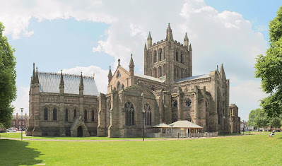
We've arrived at Hereford Cathedral, which includes some fine examples of architecture, from its Norman origins to the 20th century New Library building, with features such as four magnificent stained glass windows, a Romanesque Nave and the restored Shrine of St Thomas of Herford.
It is home to two great treasures, the Hereford Mappa Mundi and the Chained Library.
The Library is the largest surviving chained library in the world, containing about 1,500 books, dating from the 8th to early 19th centuries including many medieval manuscripts.
The Mappa Mundi is one of the most celebrated medieval maps still in existence and, at over 5 feet by 4 feet, is the largest to survive. While the image may look confusing at first glance, a simple diagram can de-mystify this and its Biblical origins. It is known as a 'T and O' map. Centred on Jerusalem, the stem of the T is the Mediterranean Sea with the Rivers Don and Nile making its crossbar. This divides the World into three continents at the time, Asia, Europe and Africa, with surrounding Ocean (the 'O').
Thus, T and O maps have the Orient at the top (hence orientation) and the British Isles are shown in the bottom left-hand corner of the map, although some imagination is needed to interpret the distorted shape.


Comments
Post a Comment